High-precision positioning even in urban areas challenging for RTK
Furuno Electric Co., Ltd. (headquartered in Nishinomiya, Japan) has commenced mass production of its dual-band GNSS※1 receiver chip, eRideOPUS 9(Model: ePV9000B), capable of achieving 50cm position accuracy without correction data.
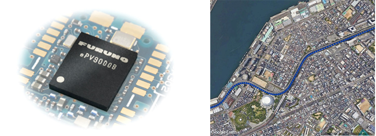
Left: The dual-band GNSS receiver chip eRideOPUS 9
Right: Track data
This product provides absolute position information that can be utilized as a reference for lane identification which is essential for service such as V2X※2 and autonomous driving (Level 2-3). It serves as a reference for determining the final self-position through cameras, LiDAR※3, and HD※4 maps. In the practical application of these services, running costs are crucial. By leveraging Furuno’s Extended Carrier Aiding※5 technology, this product achieves high-precision positioning with 50cm DRMS※6, eliminating the need for RTK※7 reference stations, correction data usage, and correction data reception components. These contribute significantly to the widespread adoption of such services which carry a high cost.
Furthermore, a dual-band GNSS module incorporating this product is being jointly developed with Alps Alpine Co., Ltd. (headquartered in Tokyo, Japan) and is scheduled for future release as the UMSZ6 series.
High-Precision Positioning of eRideOPUS 9 in Urban Areas
By enhancing our proprietary Dead Reckoning※8 technology fused with vehicle speed pulses and a 6-axis motion sensor, this product provides high-precision position information even in urban areas where RTK receivers traditionally face challenges.
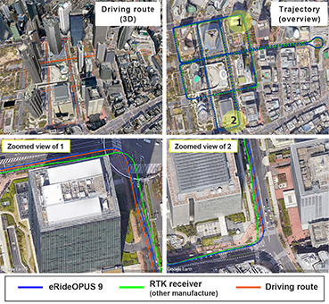
Upper left: Three-dimensional image of the urban landscape and driving route
Upper right, lower: Track Data (eRideOPUS 9 vs. other RTK receivers)
FURUNO eRideOPUS 9 Features
- Dual-band, Multi-GNSS
The eRideOPUS 9 supports all navigation satellite systems currently in operation from U.S. (GPS), Russia (GLONASS), Europe (Galileo), China (BeiDou), Japan (QZSS), and India (NavIC). In addition to L1 signals, it can receive L5 signals as well. The L5 band signals are transmitted at a chipping rate 10 times higher than L1 signals, which reduces the effects of multipath. The L5 signals also improve positioning accuracy in environments where radio waves are reflected or diffracted by structures, like in urban areas. In addition, the L5 signals have a wider frequency bandwidth, an improved signal structure, and are transmitted at a higher power than L1 signals, which makes them more resilient and allow for a more stable reception in harsh environments.
- 50cm DRMS high-precision positioning without correction data, enabling lane identification
- Anti-jamming and anti-spoofing features to provide stable position information
- Time pulse output (1PPS※9) that allows for a highly accurate synchronization between
multiple terminals during vehicle operation
For more information: https://www.furuno.com/en/products/gnss-chip/ePV9000B
About Furuno Electric Co., Ltd.
Since its incorporation in 1951, Furuno has been dedicated to development, manufacturing, and maintenance of the highest quality marine electronic equipment for navigation and communication as well as the highest precision GNSS devices, life-saving medical equipment, wireless LAN systems and much more. The FURUNO group incorporates an international workforce of approximately 3,000 employees with subsidiaries in over 30 countries, who are all prepared to fulfil the needs and expectations of our customers.
Furuno will relentlessly pursue its tradition of developing core technologies that empower customers in critical infrastructure and other fields to build robust time synchronization systems with the highest precision and reliability.
Glossary
※1 GNSS: (Global Navigation Satellite System) In addition to US GPS, there are GLONASS (Russia), Galileo (Europe), and BeiDou (China). It also includes QZSS (Japan) and NavIC (India), which are RNSS (Regional Navigation Satellite System).
※2 V2X: A general term refers to communication between a vehicle and any entity that may affect, or may be affected by, the vehicle.
※3 LiDAR: (Light Detection and Ranging) A distance measuring sensor technology that measures the distance to nearby objects using laser light such as near infrared rays.
※4 HD: High-precision 3D map for autonomous driving operation.
※5 Extended Carrier Aiding: A technology that minimizes the impact of noise. Making use of the carrier phase and dual bands, propagation delays can be significantly eliminated for reducing noise.
※6 DRMS: (Distance Root Mean Squared Error) Root Mean Squared Error.
※7 RTK: (Real Time Kinematic) A relative positioning technology. By sending data from the reference station (GNSS receiver installed at a known location) to the GNSS receiver and eliminating the systematic errors, the relative position to the reference station can be calculated with a centimeter or better level.
※8 Dead Reckoning: By combining information from various sensors such as gyro sensors and acceleration sensors, through computational processing, the technology enables precise positioning even in challenging environments for GNSS receivers.
※9 PPS: (Pulse Per Second) A pulse signal synchronized with the time of the satellite positioning system.